

If it flies, we can invert it in 3D. From passive systems such as ZTEM and AFMAG to active time domain and frequency systems we do it all. If your target is minerals, oil and gas, environment monitoring, or bathymetry, we have experience with it. We have inverted data from over 100 airborne surveys in full 3D. Locations include 6 continents in countless different geologic regimes.
AIRBORNE EM
Previously, all airborne inversions were interpreted with 1D inversion, or conductivity depth transforms. Three-dimensional inversions were too slow to be of use outside of academic studies. TechnoImaging®’s moving sensitivity domain revolutionized the field of AEM inversion and allowed entire surveys to be inverted in full 3D, which faithfully reproduces the physics of the problem. This gives the best detail and mitigates artifacts, so the geology is accurately portrayed.

3D Inversion of MEGTEM data from Kamiskotia, Ontario
Airborne Revolutionized
We offer services for the following types of data:
Helicopter Frequency Domain
RESOLVE, DIGHEM, Impulse, Aerodat, GEM2A
Fixed Wing Frequency Domain
GTK
Fixed Wing Time-Domain
TEMPEST, GEOTEM, MEGATEM, SPECTREM
Helicopter Time Domain
VTEM, HELITEM, AEROTEM, SkyTEM, HoisTEM, RepTEM, GENESIS
MobileMT
natural EM field system
Passive Airborne
AirMT, ZTEM
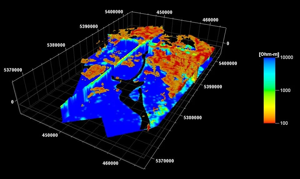
3D Inversion of MEGTEM data from Kamiskotia, Ontario
What We Offer
TechnoImaging® is the only service provider that inverts active airborne data in 3D with full 3D electromagnet field modeling. Do you have multiple components or even multiple systems over same area? We interpret the airborne EM data jointly for conductivity and induced polarization parameters. We can simultaneously invert multicomponent time and frequency domain data for the best resolution of your geologic target.