

EMVISION®
The software package by TechnoImaging® that allows for processing, 3D inversion and 3D modeling of all kinds of geophysical data. EMVision® makes it possible to transform data sets of any size, including extremely large surveys, with the option of the integration and joint inversion of different types of geophysical data.
EMVision® features the following:
High stability and accuracy in 3D modeling with the suite of numerical methods, including integral equation, finite difference, and finite element techniques
Large-scale 3D inversion with fine grids by using the moving sensitivity domain approach
Integrated geophysical model based on multimodal geophysical data with joint 3D inversion using Gramian and joint focusing constraints
Sharp, focused images with 3D focusing regularization
Parallelized and optimized for the in-house powerful TechnoImaging®’s PC cluster
3D resistivity model obtained by inversion of airborne EM data
Large-scale 3D Airborne Electromagnetic (AEM) Inversion
3D inversion of entire AEM surveys to models with millions of cells, delivered in industry standard formats
RESOLVE, DIGHEM, VTEM, AEROTEM, HELITEM, SkyTEM, TEMPEST, GEOTEM, MEGATEM, SPECTREM
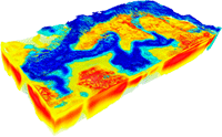
The Largest Joint 3D Gravity and Magnetic Inversion
3D inversion of regional surveys to models with hundreds of millions of cells, delivered in industry-standard formats
Gravity, Gravity Gradiometry, Magnetics, Magnetic Gradiometry

Entire Vredefort structure is discretized to over 350 M cells. The figure shows a horizontal section of 3D density model at 1500 m depth produced by inversion of the FTG airborne survey.

3D inversion of the EarthScope MT data
The Largest Join 3D Magnetotelluric (MT) and ZTEM Inversion
3D inversion to models with millions of cells, delivered in industry standard formats
Principle Components, Full Tensor, Tipper
MT, AMT, ZTEM
Large-scale 3D Marine Controlled-Source Electromagnetic (MCSEM) Inversion
3D inversion of entire surveys to models with millions of cells, delivered in industry-standard formats
Frequency-domain CSEM, Time-domain CSEM, Towed Streamer EM
3D inversion of marine towed streamer EM data
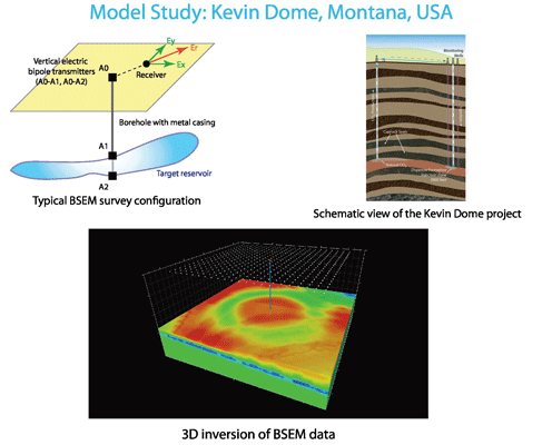
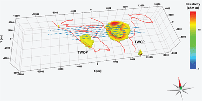
Large-scale 3D Borehole-to-Surface EM Data Inversion
Multiple component BSEM data
Interpretation of exploration, appraisal and monitoring BSEM surveys
Downhole EM